Monday, 20 October 2014

Restaurant near Sanyou Cave above the Chang Jiang river, Hubei , China

101 Most Beautiful Places You Must Visit Before You Die!   part 1

Fangweng Restaurant is located in China, in Hubei Province, about 12km north of the city of Yichang, near Sanyou Cave, or “The Cave of the Three Travelers”. The restaurant is in the Happy Valley of the Xiling Gorge, an especially scenic stretch of cliffs, caves and park land located around the area where the Chang Jiang River flows into the Yangtze. The entrance to the Fangweng Restaurant is an uninspiring grey brick building, but at the far end of a narrow concrete bridge, the restaurant caves into the cliff, the floor hanging several hundred feet above the ground. From this end, customers can view the flowing water of Yangtze River. For the daredevils, a bungee jumping platform is nearby.
fangweng-restaurant-1
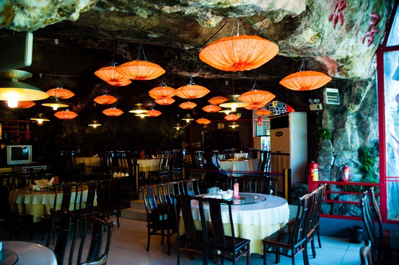
Walking into the restaurant and down the steps, one will come to a natural “cave lobby”. Rightward, a 30-meter-long plank road has been built along the cliffside. It leads to another natural cave, which has been transformed into a dining hall. Warm lighting from the ceiling lends a golden yellow glow throughout. Dimly lit and Chinese-style furnishings blend in with its surroundings. Part of the dining hall hangs out of the cave, where some dining tables are placed. This is a place sitting high in the air, where the flowing waters can be watched from above.
The restaurant gets its name from Lu You, a great poet from Southern Song dynasty (1127-1279). It is said that he had brewed tea in a cave on the mountainside.
fangweng-restaurant-6


Capilano Suspension Bridge, Vancouver, British Columbia

101 Most Beautiful Places You Must Visit Before You Die!   part 1

    The Capilano Suspension Bridge is a simple suspension bridge crossing the Capilano River in the District of North VancouverBritish ColumbiaCanada. The current bridge is 140 metres (460 ft) long and 70 metres (230 ft) above the river. It is part of a private facility, with an admission fee, and draws over 800,000 visitors a year.
     The bridge was originally built in 1889 by George Grant Mackay, a Scottish civil engineer and park commissioner forVancouver. It was originally made of hemp ropes with a deck of cedar planks, and was replaced with a wire cable bridge in 1903. In 1910 Edward Mahon purchased the Capilano Suspension Bridge. "Mac" MacEachran purchased the Bridge from Mahon in 1935 and invited local natives to place their totem poles in the park, adding a native theme. In 1945, he sold the bridge to Henri Aubeneau.
The bridge was completely rebuilt in 1956.[2]
The park was sold to Nancy Stibbard, the current owner, in 1983. Annual attendance has since increased, and in May 2004, Treetops Adventures was opened. This new attraction consists of seven footbridges suspended between old-growth Douglas Fir trees on the west side of the canyon, forming a walkway up to 30 metres (98 ft) above the forest floor.
     As well as the bridge and Treetops Adventure, the first venue of its kind in North America, the park also features rain forest ecotours, award-winning gardens, nature trails, North America's largest private collection of First Nations totem poles, period decor and costumes, and exhibits highlighting the park's history and the surrounding temperate rain forest. Guests can also witness a First Nations performance, featuring their traditional Regalia (ceremonial dress), masks, dancing and storytelling.
In June 2011, a new attraction called Cliff Walk was added to the park. This adventures is free and comes as a bundle along with the other attractions.

Enjoy walk and feel free to comment and like my posts.

Antelope Canyon, USA

101 Most Beautiful Places You Must Visit Before You Die!   part 1

   Located near Lake Powell, this "slot" canyon is considered sacred by the Navajo.
         Antelope Canyon is a small but exquisitely beautiful geological formation in northern Arizona. It is not a national or state park and is often overlooked by many tourists visiting the area. It takes only an hour or two to see it all, but it is worth the time. Its unsurpassed beauty is breathtaking. It is a photographer's dream.
Antelope Canyon is located a few miles of east of Page, Arizona. Actually there are two antelope Canyon's located on either side of route 98. Upper Antelope Canyon and Lower Antelope Canyon are both owned by the Navajo Nation. Unfortunately, they charge separate entry fees of about $18 per person for each part of this attraction. Since the upper and lower canyons are very similar, you need visit only one.
        Page Arizona is located on the Utah border of North Central Arizona. This small desert community is primarily known as the location of the Glen Canyon Dam and the gateway to theLake Powell recreational area. It is about two hours from Monument Valley, two hours from the North Rim of the Grand Canyon, three hours from the South Rim of the Grand Canyon, two hours from Zion National Park and four hours fromLas Vegas.
The entrances to upper and lower Antelope Canyon are easy to miss. Only small signs along route 98 mark these attractions. They are located about five miles east of Page just before the great Navajo power generating plant. A small admissions booth and a parking lot are the only noticeable features in the desert landscape.
Antelope Canyon, Arizona© Mike Leco / USATourist.com
The sandstone bedrock has been intricately carved by the infrequent but often violent flow of water.
       As you approach the Canyon on foot, it is almost unnoticeable from even a few meters distance. You see only a small crack in the rock at the bottom of a dry streambed. Closer inspection reveals a small metal ladder descending into the crack. It is barely wide enough for a person to squeeze through. A series of ladders and stairs takes you down into an unbelievably narrow canyon.
     The sandstone bedrock has been intricately carved by the infrequent but often violent flow of water. It is sculpted into beautiful undulating curves and hollows that vary from one to three meters wide by up to 50 meters deep. The sunlight filtering down from above produces a myriad of soft colors and shadows. The effect is exquisitely beautiful. This is a photographer's wonderland.
    You can follow the single passageway in this canyon for about a half a mile. Take your camera and plenty of film!

Written by: Pushpak Bora

Bridge at summit, Langkawi

101 Most Beautiful Places You Must Visit Before You Die!   part 1

          Langkawi Sky Bridge is a 125-metre (410 ft) curved pedestrian cable-stayed bridge in Malaysia, completed in 2005. It is located 700 metres (2,300 ft) above sea level at the peak of Gunung Mat Chinchang on Pulau Langkawi, an island in theLangkawi archipelago in Kedah. The last scene of Indian movie Don: The Chase Begins Again was filmed here.The Langkawi Sky Bridge is accessible by the Langkawi Cable Car.
    The skybridge has been closed for the last 2 years and remains closed in 2014 for renovations and maintenance and may not reopen.
Watch video and be free to comment @ pushpaksforeigntour.blogspot.in

Sunday, 19 October 2014

Carrera Lake (Lake Buenos Aires), Santa Cruz, Argentina

101 Most Beautiful Places You Must Visit Before You Die!   part 1

Buenos Aires or General Carrera is a lake located in Patagonia and shared with Argentina, where it is known under the name of Lago Buenos Aires, and Chile, where it is known as Lago General Carrera. Both names are internationally accepted.
The lake has an area of 1850 square kilometers, from which 970 square kilometers are in the Chilean region Aisén, and 880 square kilometers are in the Argentine province of Santa Cruz, making it the largest lake in Chile and the fourth largest in Argentina. In its western basin, the lake General Carrera has a maximum depth of 586 meters.
The lake is of glacial origin and is surrounded by the Andes mountain chain. The lake flows into the Pacific Ocean to the west, through the Baker River.
The weather in this part of Chile and Argentina is generally cold and wet, but the lake itself has a sunny microclimate.
The lake is known as a destination for trout and salmon fishing and for the Marble Cathedral (marble cave) located in the center of the lake.
The Marble Cathedral is a marvel of nature located on Lake General Carrera, consisting of an intricate system of caves and natural rock sculptures on the background of azure and clear waters.
Those who have passed through this area say that every time, the experience is completely different than the previous one because of the light that dresses in multiple nuances the stone shapes of the caves.
Because of the increasing number of tourists who come here every year, the Chilean government decided to impose visiting restrictions. Unfortunately, not only the uncivilized tourists are a threat to these magical places, but even the civilization itself: in the environmental circles the members speak about the electrification projects in the area that are destroying this natural wonder of Lake Carrera.


Angkor Thom – Baphuon Temple, Cambodia

101 Most Beautiful Places You Must Visit Before You Die!   part 1
                 Literally: "Great City", located in present day Cambodia, was the last and most enduring capital city of the Khmer empire. It was established in the late twelfth century by King Jayavarman VII. It covers an area of 9 km², within which are located several monuments from earlier eras as well as those established by Jayavarman and his successors. At the centre of the city is Jayavarman's state temple, the Bayon, with the other major sites clustered around the Victory Square immediately to the north.
    Angkor Thom was established as the capital of Jayavarman VII's empire, and was the centre of his massive building programme. One inscription found in the city refers to Jayavarman as the groom and the city as his bride.
The last temple known to have been constructed in Angkor Thom was Mangalartha, which was dedicated in 1295. Thereafter the existing structures continued to be modified from time to time, but any new creations were in perishable materials and have not survived. In the following centuries Angkor Thom remained the capital of a kingdom in decline until it was abandoned some time prior to 1609, when an early western visitor wrote of an uninhabited city, "as fantastic as theAtlantis of Plato".[1]:140 It is believed to have sustained a population of 80,000–150,000 people.

Monday, 6 October 2014

Infinite Pool, Hotel Marina Bay Sands, Singapore

101 Most Beautiful Places You Must Visit Before You Die!   part 1

INFINITY POOL
Swim on Top of the World
View a virtual tour of the stunning Sands SkyPark Infinity Pool located 57 storeys above the ground.
6am - 11pm daily
Experience one of the world's most amazing hotel rooftop pools. Stretching an impressive 150 metres across Sands Skypark, the stunning outdoor Infinity Pool designed by renowned architect Moshe Safdie is the world's largest at this height and offers the best city-skyline view of of a 5-star hotel in Singapore.
Whether you want to lounge, socialise or play, the Infinity Pool offers all the pleasures of a hotel stay well-spent.

The Subway, Zion National Park, Utah

101 Most Beautiful Places You Must Visit Before You Die!   part 1


There are two ways to explore The Subway (the Left Fork of North Creek). Permits are required regardless of the direction of travel. Both trips involve extensive route finding. Visitors are encouraged to do the trip with an experienced hiker of The Subway or obtain a detailed route description. The Subway is a day-use area only.

From the Bottom Up
This is a strenuous 9-mile round-trip hike through the Left Fork of North Creek that requires route finding, creek crossing, and scrambling over boulders. This hike begins and ends at the Left Fork Trailhead on the Kolob Terrace Road.

From the Top Down
This is a strenuous 9.5-mile hike that requires rappelling skills, 60 feet of rope, and extensive route finding experience. The route also requires swimming through several deep pools of very cold debris-filled water. The trail begins at the Wildcat Canyon Trailhead and ends at the Left Fork Trailhead. Both trailheads are located on the Kolob Terrace Road.

Also check the video uploaded of the above post : 

Feel free to comment and subscibe.

Bora Bora

   101 Most Beautiful Places You Must Visit Before You Die!   part 1

Bora Bora is an island in the Leeward group of the Society Islands of French Polynesia, an overseas collectivity of France in the Pacific Ocean. The island, located about 230 kilometres (143 miles) northwest of Papeete, is surrounded by a lagoon and a barrier reef. In the centre of the island are the remnants of an extinct volcano rising to two peaks, Mount Pahia and Mount Otemanu, the highest point at 727 metres (2,385 feet).
Bora Bora is a major international tourist destination, famous for its aqua-centric luxury resorts. The major settlement, Vaitape, is on the western side of the main island, opposite the main channel into the lagoon. Produce of the island is mostly limited to what can be obtained from the sea and the plentiful coconut trees, which were historically of economic importance for copra. According to a 2008census, Bora Bora has a permanent population of 8,880.
Friends enjoy the awesome shoot uploaded by me to the post : 

Feel free to comment and subscibe to my blog

Nishinomaru Garden in Japan

101 Most Beautiful Places You Must Visit Before You Die!   part 1


Nishinomaru Garden is Osaka's most popular location for cherry blossom viewing and Hanami Parties. Nishinomaru Garden features around 600 cherry trees, including someiyoshino (the most popular variety of sakura (cherry blossom) in Japan) and around 95 kinds of Japanese apricot flowers. Nishinomaru Garden is located within the greater Osaka Castle Park between the Outer Western Moat and the Inner Moat of Osaka Castle. Nishinomaru Garden was opened in 1965. It is the site of the former residence of Kita-no-mandokoro (wife of Toyotomi Hideyoshi, a Japanese ruler in the 16th century). Nishinomaru Garden covers an area of approximately 64,000 m2, combining open expanses of grass and the 600 cherry trees set against the background of the castle tower and the stone walls of a moat. The scenery, which changes from season to season, attracts many visitors throughout the year. While spring brings the bright colors of cherry blossom to Osaka Castle Park, autumn brings the beautiful colors leaves. During the cherry blossom season (normally early April) the garden is open in the evening.
Opening Times:
9:00am - 5:00pm; Close: Mondays
Entrance Fees:
200 Yen
Address:
Chuo Ward, Osaka, Osaka Prefecture.
Directions:
5 min walk from Osakajo-koen Station (JR Osaka Loop Line)

Map:
Nishinomaru Garden Map including surrounding attractions see.

Also see the video uploaded by me for the post : 


Feel free to comment and subscibe to the blog.....

Sunday, 5 October 2014

Natural Pool - Santorini, Greece

cave-pool-in-santorini-greece-2013-travel-destinations-great-atmosphere-1

Natural_Pool_Santorini_Greece_amazaing_view_2013_travel_destinations_photography-1

Mount Emei Scenic Area: Leshan Giant Buddha, China

                        101 Most Beautiful Places You Must Visit Before You Die!   part 1

The Leshan Giant Buddha is a 71-metre (233 ft) tall stone statue, built during the Tang Dynasty. It is carved out of a cliff face that lies at the confluence of the Minjiang,Dadu and Qingyi rivers in the southern part of Sichuan province in China, near the city of Leshan. The stone sculpture facesMount Emei, with the rivers flowing below his feet. It is the largest stone Buddha in the world[1] and it is by far the tallest pre-modern statue in the world.
The Mount Emei Scenic Area, including Leshan Giant Buddha Scenic Area has been listed as a UNESCO World Heritage Sitesince 1996.
The video has been uploaded be there: 

Feel free to comment

Glacier National Park, Montana

101 Most Beautiful Places You Must Visit Before You Die!   part 1

Glacier National Park is located in the U.S. state of Montana, south from the Canadian borders of Alberta and British Columbia. The park encompasses over 1,000,000 acres (4,000 km2) and includes parts of two mountain ranges (sub-ranges of the Rocky Mountains), over 130 named lakes, more than 1,000 different species of plants and hundreds of species of animals. This vast pristine ecosystem is the centerpiece of what has been referred to as the “Crown of the Continent Ecosystem”, a region of protected land encompassing 16,000 square miles (41,000 km2). The region that became Glacier National Park was first inhabited by Native Americans and upon the arrival of European explorers, was dominated by the Blackfeet in the east and the Flathead in the western regions. Soon after the establishment of the park on May 11, 1910, a number of hotels and chalets were constructed by the Great Northern Railway. These historic hotels and chalets are listed as National Historic Landmarks, and a total of 350 locations are on the National Register of Historic Places. By 1932, work was completed on the Going-to-the-Sun Road, later designated a National Historic Civil Engineering Landmark, which provided greater accessibility for automobiles into the heart of the park.
 Glacier National Park, Montana

 Glacier National Park, Montana

 Glacier National Park, Montana

 Glacier National Park, Montana

 Glacier National Park, Montana

Video has been uploaded play and enjoy :

Feel free to comment and ask.


Plitvice Lakes National Park, Croatia

101 Most Beautiful Places You Must Visit Before You Die!   part 1
Plitvice Lakes National Park  is the oldest national park in Southeast Europe and the largest national park in Croatia. The national park was founded in 1949 and is situated in the mountainous karst area of central Croatia, at the border to Bosnia and Herzegovina. The important north-south road connection, which passes through the national park area, connects the Croatian inland with the Adriatic coastal region.
Plitvice Lakes National Park, Croatia

Plitvice Lakes National Park, Croatia

Plitvice Lakes National Park, Croatia

Plitvice Lakes National Park, Croatia

Plitvice Lakes National Park, Croatia

Video Has also been posted here watch and feel it:

Santorini, Greece

101 Most Beautiful Places You Must Visit Before You Die!   part 1
Santorini is an island in the southern Aegean Sea, about 200 km (120 mi) southeast of Greece's mainland. It is the largest island of a small, circular archipelago which bears the same name and is the remnant of a volcanic caldera. It forms the southernmost member of the Cyclades group of islands, with an area of approximately 73 km2 (28 sq mi) and a 2011 census population of 15,550. The municipality of Santorini comprises the inhabited islands of Santorini and Therasia and the uninhabited islands of Nea Kameni,Palaia Kameni, Aspronisi, and Christiana. The total land area is 90.623 km2 (34.990 sq mi). Santorini is part of the Thira regional unit.[2]

Santorini is essentially what remains after an enormous volcanic eruption that destroyed the earliest settlements on a formerly single island, and created the current geological caldera. A giant central, rectangular lagoon, which measures about 12 by 7 km (7.5 by 4.3 mi), is surrounded by 300 m (980 ft) high, steep cliffs on three sides. The main island slopes downward to the Aegean Sea. On the fourth side, the lagoon is separated from the sea by another much smaller island called Therasia; the lagoon is connected to the sea in two places, in the northwest and southwest. The depth of the caldera, at 400m, makes it possible for all but the largest ships to anchor anywhere in the protected bay; there is also a newly built marina at Vlychada, on the southwestern coast. The island's principal port is Athinias. The capital, Fira, clings to the top of the cliff looking down on the lagoon. The volcanic rocks present from the prior eruptions feature olivine and have a small presence of hornblende.
You May have look at this island as video has been displayed below: